Hackney Council’s Geographical Information Systems (GiS) team have put together a special GitHub for Hack-ney-thon 2014 (https://github.com/LBHackney/Hack-ney-thon) with lots of data on local services and planning.
About the Geographical Information Systems (GiS) team
A Geographic Information System“ (GIS), captures, stores, analyzes, manages, and presents data that refers to or is linked to a location. In the strictest sense, the term describes any information system that integrates, stores, edits, analyzes, shares, and displays geographic information. In a more generic sense, GIS applications are tools that allow users to create interactive queries (user created searches), analyze spatial information, edit data, maps, and present the results of all these operations.
The council is committed to meet the specifications of the EU’s INSPIRE Directive (Infrastructure for Spatial Information in the European Community –http://inspire.ec.europa.eu/). Through their work the GiS team have developed several tools such as; Map.Hackney2.0; MapGallery; Plan Web and the resident facing Find My Nearest (http://www.map.hackney.gov.uk/Find-My-Nearest/) – an interactive mapping tool using council, OpenStreetMap and Ordnance Survey data. You can find out more about their interactive map projects here.
What’s on the GitHub?
The GitHub can be found here: https://github.com/LBHackney/Hack-ney-thon
The data made available to the hack relates mostly to the council’s work on http://www.map.hackney.gov.uk/maphackney3/. This is a collation of both open and newly gathered data on the local area. The menu below gives an indication of the types of information to be found, things like local services and amenities, transport links and importantly a significant amount of data on historic and current planning applications.
- *Base Layers
- __>OpenStreetMap
- __>Ordnance Survey
*Overlays
__>Hackney Wards
__>Hackney Parks
*Housing Neighbourhoods
__>Water Regions
__>OS 500m Grid
__>OS 1Km Grid
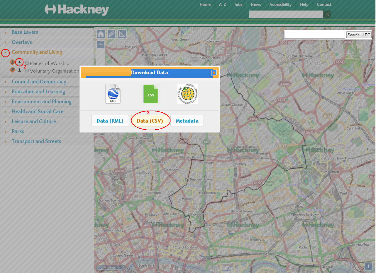
*Community and Living
__>Places of Worship
__>Voluntary
*Council and Democracy
_>Polling Stations
*Education and Learning
__>Nurseries
__>Primary Schools
__>Secondary Schools
__>Colleges
__>Independent Schools
__>Libraries
*Environment and Planning
__>Listed Buildings
__>Tree Preservation Orders - __>Pollution
- __>LDF
- __>Planning Applications
- __>Growth Centres
__>Recycling
__>Conservation Areas
*Health and Social Care
__>Dental Surgeries
__>General Practice
__>Opticians
__>Pharmacies
*Leisure and Culture - __>Exercise and KeepFit
- __>Football
- __>Leisure Centres
- __>Sports Club
- __>Swimming
- __>Table Tennis
- __>Tennis
- __>Water Sports
- __>Youth Clubs
- *Parks
- __>Bins
- __>Seating
- __>Lighting
- __>Bollards
- __>Signs
- __>Drains
- *Transport and Streets
- __>Bus Stops
- __>Cycle Stands
- __>Car Club Bays
- __>Barclays Hire Bike Stands
- __>Cycle Network
- __>Controlled Parking Zones
- __>Disabled Parking Bays
- __>Train Stations
- __>Underground Stations
The files are available on GitHub in Geojson and you can also download .csv files directly here: http://www.map.hackney.gov.uk/maphackney3/. See the below image on how to save them to your desktop.
In addition, the GiS team have also put together a small list of data they have gathered from elsewhere: https://github.com/LBHackney/Hack-ney-thon/wiki/External-Datasets. This includes; Edubase education data, an education API from TSO OpenUpLabs, Ordnance Survey OpenData and Tfl Open Data.